Your aerial imaging specialist
We deliver top-quality aerial imagery that exceeds customer expectations.
In this case study, we highlight how Digisky’s innovative aerial surveying solution transformed the subdivision development process for a 47-hectare farm with challenging terrain. By combining traditional surveying with our accurate Digital Surface Model (DSM), we provided substantial time and cost savings, leaving the surveying company thoroughly satisfied with the results.
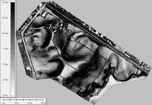
The surveying company faced the task of mapping a vast 47-hectare farm with varying elevations, including hills and challenging terrain. Traditional surveying methods would have been time-consuming and expensive, requiring substantial human resources and equipment.
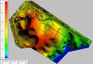
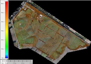
Digisky proposed an aerial surveying approach to complement traditional methods, combining the advantages of both to deliver precise results efficiently. Our drone-based aerial survey captured high-resolution images and data, which we transformed into an accurate Digital Surface Model (DSM) of the entire farm.
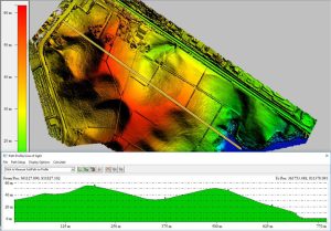
The engineers utilized our DSM to load the farm’s surface information into the digging machines. This enabled precise grading and earthmoving during the subdivision development. By leveraging our DSM, the engineers saved time and streamlined their processes, resulting in cost-effective and well-planned construction.
The synergy of traditional and aerial surveying, along with the use of our DSM, significantly reduced the time required for the surveying company to complete their tasks. The efficiency gains translated into substantial cost savings, making the entire project economically viable.
The surveying company expressed overwhelming satisfaction with the aerial surveying approach. Our solution not only saved them valuable time but also optimized their resources and budget. They praised the seamless integration of our DSM into the engineering phase, simplifying their work and ensuring accurate results.
The successful collaboration between Digisky and the surveying company demonstrates the transformative impact of aerial surveying in subdivision development. By combining traditional surveying with our precise DSM, we offered an innovative and cost-effective solution that streamlined processes and optimized resources. The time and money saved through our aerial surveying approach reaffirms our commitment to providing efficient and impactful geospatial solutions for a wide range of projects.
We deliver top-quality aerial imagery that exceeds customer expectations.