Your aerial imaging specialist
We deliver top-quality aerial imagery that exceeds customer expectations.
At Digisky, we often work with large organizations and companies to provide them with cutting-edge GIS solutions. However, when a passionate orchardist approached us, we saw an opportunity to extend the benefits of our technology to a smaller scale. This case study explores how we assisted an orchardist with limited computer and GIS knowledge in mapping and developing his kiwi orchard, ultimately helping him save time, energy, and costs.
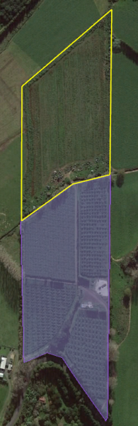
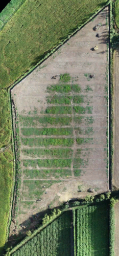
The orchardist owned a 4.5ha kiwi orchard and aimed to
expand it by an additional 3.6ha. Despite lacking familiarity with GIS
applications, he wanted to map the new development, conduct measurements remotely, and estimate fencing and adjustment costs. Our challenge was to provide a user-friendly solution that catered to his needs and capabilities.
To ensure our client could take full advantage of the benefits, we offered a short tutorial on how to work with our files. This tutorial guided him through making measurements and effectively utilizing the GIS data. Additionally, we created a simple, step-by-step tutorial on drawing, measuring, and sharing polygons within Google Earth Pro. We made this valuable resource available for download on our website, extending the benefits to other readers who might find it helpful.
“Drawing and Exporting Polygons Made Easy with Google Earth Pro”
Our mission at Digisky is to democratize GIS technology and make it accessible to all, regardless of technical expertise. By providing accurate ortho-rectified images and user-friendly tutorials, we aim to empower even those who are not tech-savvy. This case study is a testament to our commitment to inclusivity and our dedication to helping all clients, big or small, achieve their goals.
This case study highlights how GIS technology can transform the fortunes of small-scale orchardists. By assisting our client with mapping and measuring his kiwi orchard, we enabled him to save time and costs while optimizing his development plans. At Digisky, we believe that everyone should have access to powerful geospatial solutions, and we are proud to have contributed to the success of this passionate orchardist.
We deliver top-quality aerial imagery that exceeds customer expectations.