Your aerial imaging specialist
We deliver top-quality aerial imagery that exceeds customer expectations.
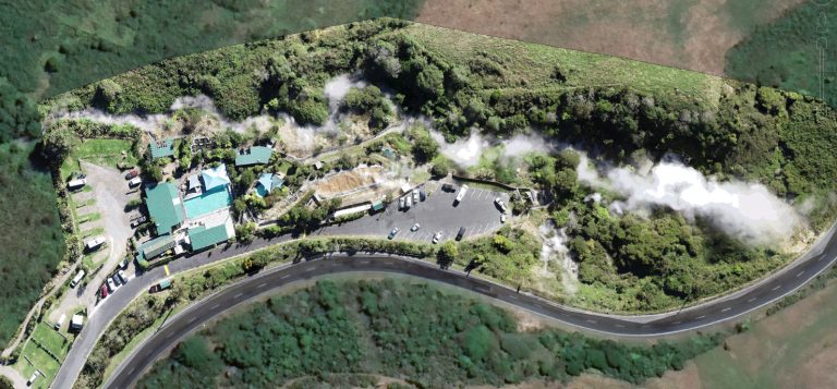
In this case study, we explore how Digisky assisted a geothermal consultant in designing new piping for a geothermal spa situated in Rotorua’s outskirts. The client’s primary objective was to determine the elevation differences between strategic locations within the site to ensure the correct sizing and gradient for the piping system. Leveraging advanced geospatial tools, we provided the client with accurate data and profile lines, facilitating an optimized and efficient piping design.
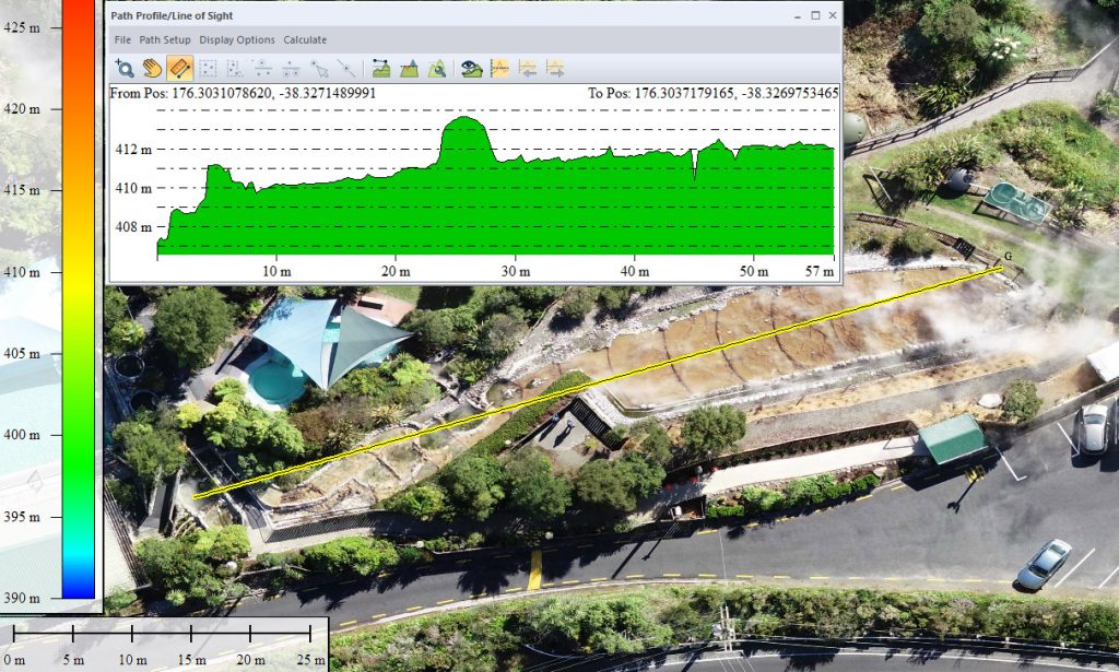
The geothermal consultant faced the challenge of accurately measuring the elevation differences between key points on the site. These elevation variations were crucial in determining the appropriate pipe sizes and ensuring efficient water flow within the spa’s geothermal system. Traditional surveying methods could be time-consuming and expensive, making it essential to find an efficient and accurate alternative.
Digisky offered a cutting-edge solution by providing the geothermal consultant with an ortho-rectified image of the site. This image allowed the client to precisely locate the strategic points for analysis. Additionally, we supplied a Digital Surface Model (DSM) that captured elevation data, enabling us to calculate elevation differences between each point of interest.
By leveraging the DSM data, we were able to generate detailed profile lines that showcased the elevation changes along specific paths. These profile lines offered a clear visualization of the terrain’s undulations, providing valuable insights into the site’s topography.
Through our geospatial expertise, the geothermal consultant achieved the following benefits:
· Precise Elevation Measurements: The ortho-rectified image and DSM data enabled precise and reliable elevation measurements, streamlining the design process.
· Cost-Effective Solution: By utilizing drone-based imagery and geospatial tools, the client avoided costly and time-consuming traditional surveying methods.
· Enhanced Design Accuracy: The profile lines provided a comprehensive understanding of the site’s terrain, aiding in the creation of a well-informed and efficient piping design.
The successful collaboration between Digisky and the geothermal consultant showcases the value of geospatial technology in optimizing infrastructure design. By providing accurate elevation data and detailed profile lines, we contributed to the efficiency and effectiveness of the geothermal spa’s piping design. This case study underscores the importance of leveraging advanced tools for engineering projects, empowering businesses to make informed decisions and achieve outstanding results.
We deliver top-quality aerial imagery that exceeds customer expectations.