Your aerial imaging specialist
We deliver top-quality aerial imagery that exceeds customer expectations.
In this case study, we explore how Digisky’s aerial services revolutionized stockpile volume monitoring for a quarry manager, providing numerous benefits, particularly in health and safety. By replacing traditional ground surveying methods with our high-resolution aerial imagery, the quarry manager witnessed increased efficiency, minimized operational disruptions, and substantial cost savings.
The quarry manager faced the crucial task of monitoring stockpile volumes for quarterly reports. Traditional ground surveying methods involved manual measurements and traversing through active quarry zones, which posed significant health and safety risks and required halting ongoing operations.
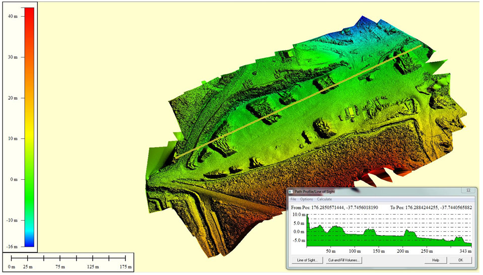
Digisky proposed an aerial surveying approach to address the challenges of stockpile monitoring. By utilizing drone-based aerial services, we provided a safe and efficient solution for capturing high-resolution imagery of the entire quarry area, including stockpiles and the grinding facility.
With our aerial services, there was no need to wander through the active quarry area while trucks were loading materials. This significantly reduced the exposure of personnel to potential hazards, improving overall health and safety compliance. Aerial surveys also allowed for non-disruptive monitoring of stockpile volumes, avoiding any need to stop operations.
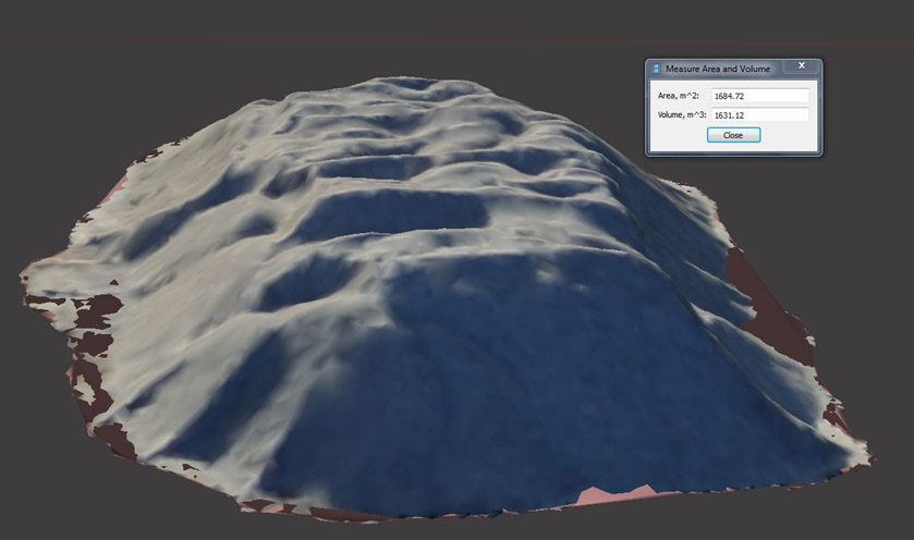
Our high-resolution imagery enabled precise volume quantification of stockpiles being processed in the grinding facility. The data collected through aerial surveys proved to be invaluable for generating quarterly reports, enabling better decision-making and resource allocation.
In addition to stockpile monitoring, the aerial imagery provided comprehensive records of the quarry site. This served as a valuable resource for future reference and planning. Furthermore, our aerial services proved to be more cost-effective compared to traditional surveyors, offering the quarry manager substantial cost savings.
The successful implementation of Digisky’s aerial services for stockpile monitoring showcases the tremendous advantages it brings to quarry management. By replacing traditional ground surveying, we significantly improved health and safety standards, minimized operational disruptions, and provided accurate data for reporting and decision-making. Our cost-effective approach and high-resolution imagery reaffirm our commitment to delivering cutting-edge geospatial solutions, empowering businesses like the quarry manager to optimize their operations and achieve remarkable results.
We deliver top-quality aerial imagery that exceeds customer expectations.